Welcome to the blog of writer and musician Andrew Martin. Here I'll post original photographs and observations as I encounter the history and culture of the San Fernando Valley, the City of the Angels, Alta California and the far-flung Pacific Rim… but mostly the Valley.
La plu ca change…. Water rights in So Cal have been a much-discussed and much-written-about subject. All political decisions regarding the lion’s share of the region’s water were vested, in 1781, with the municipality of Los Angeles. We know that story: zanjas, zanjeros and aqueducts; wine and brandy flowing from Los Angeles while dry ranches were forced to dry farming; lush orange groves follow Mulholland; then dams, floods, the U.S. Army Corps of Engineers, and millions of green front lawns.
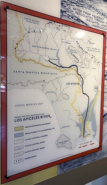
Nevertheless, man proposes, God disposes. Sometimes even the mighty ayuntamiento of the Angels is powerless before the grand forces of plate tectonics and hydrogeology. In 1825, the course of the Los Angeles River was shaken by an earthquake.
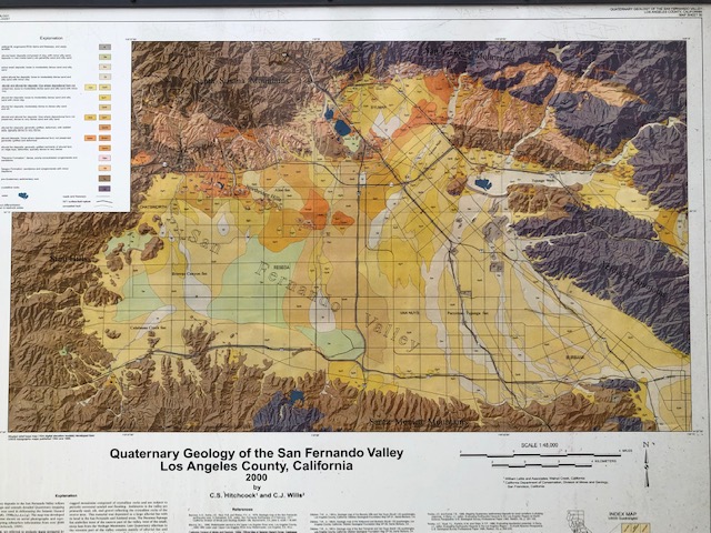
See how the original course of the river through West LA , is still marked as an area that is vulnerable to potential flooding of the LA River system. The river might just want to find its old course someday.
The former course, across Beverly Hills and Culver City, turned from a flowing river to a soggy, swampy marsh — Las Cienegas. This watered land, now without municipal restrictions, led to a flurry of water-meady grants in the area. Las Cienegas, Cienega o Paso La Tijera, Rodeo de las Aguas (“gathering of the waters”), Aguaje de La Centinela.
Among many other things, the change of course allowed the City of Los Angeles to take legal control of land adjacent to the river course — and the associated transit rights — all the way down to the port of San Pedro/Long Beach. After the City won the “Port Fight,” and cleared out the sand bar blocking San Pedro Bay, this previously remote fishing cove grew into America’s #1 port. Had El Rio not changed course, the City would not have had a legal claim to the sheltered lagoons of San Pedro; but to the broad Santa Monica Bay, which, although a magnificent tourist beach, is nothing but a wide-open shallow roadstead that would have been almost useless as a major U.S. commercial port of entry.
Nature contributes the sea, the sun and the wind; but the astonishing gardens on the cliffs are the legacy of three fascinating individuals, each, in a way, a genius. Each is well-known in the history of the region, for doing other things. The garden was merely a happy accident in each of their lives, but in the view of posterity, these bluffs have become a grace upon the coast Southern California, and the credit of our gratitude is due.
Until 1872, the mesas overlooking Santa Monica Bay were part of the Rancho San Vicente y Santa Monica, the rich grasslands of the Sepulvedas; and Rancho Boca de Santa Monica, the equally lush ranges of the Marquez family. The vague grants overlapped by several thousand acres; and disputes before the (notorious) U.S. Land Commission were not settled until 1872, when the ranchos were consolidated, parceled, and sold off. The principal buyers had big plans for the sun-drenched coastal cliffs.
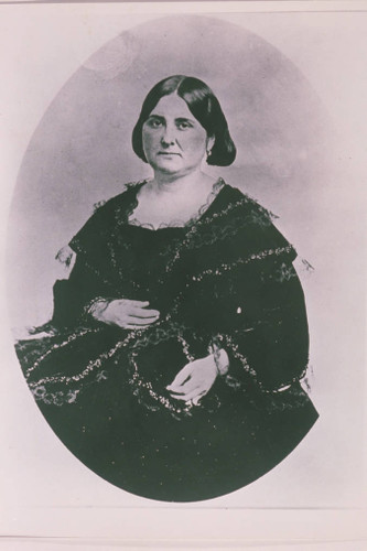
Arcadia Bandini de Stearns Baker
Sen. John P. Jones
Chief visionary was Dona Arcadia Bandini de Stearns Baker, a true grande dame, the social lioness of the Old Californio Families. Arcadia foresaw luxury hotels, wealthy retirees, and pleasure gardens in her new city. But her partner was mining magnate and Montana Republican Senator, John Percival Jones, who hoped to turn Santa Monica into the Entrepot of the Pacific, distribution hub of the combined products of North America and Asia. Jones conspired with the Southern Pacific’s Collis P. Huntington to build the Long Wharf rail terminus right at the bottom of the cliffs. They hoped a bustling port-railhead on Santa Monica Beach would eat San Pedro’s lunch (see “Los Angeles Harbor Fight.”)
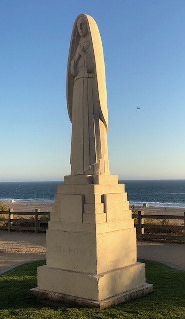
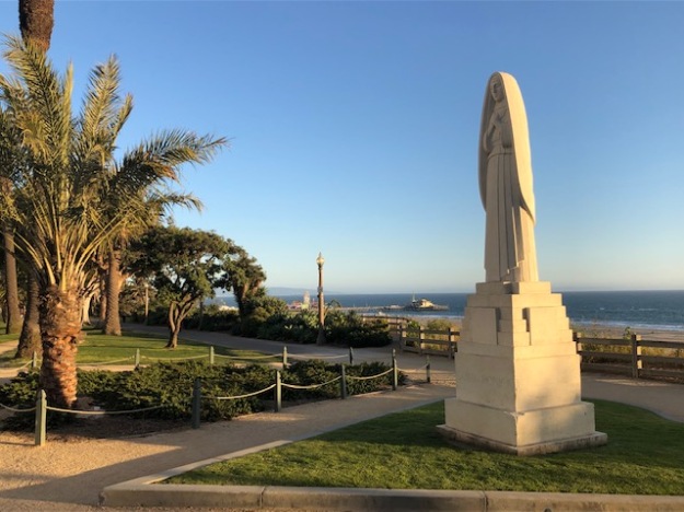
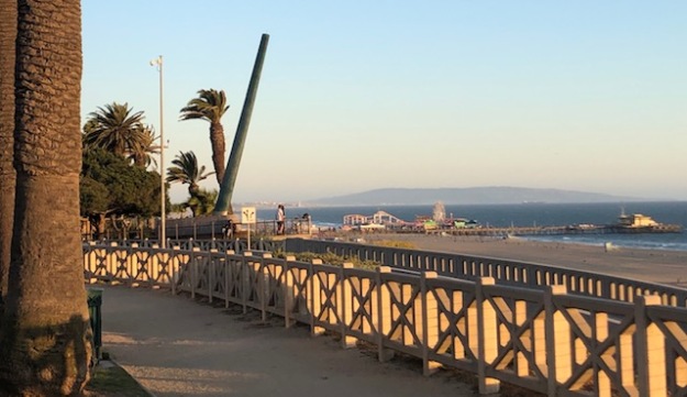
“Santa Monica”
Eugene Morahan, sculptor. WPA, 1934.
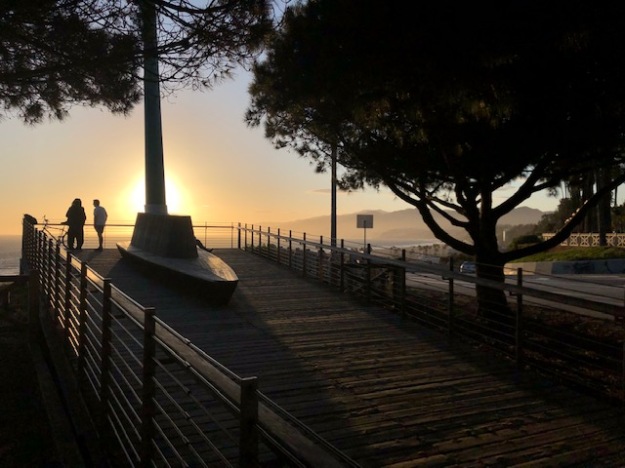
These formidable speculators named their city, as did the rancheros, for twin springs (now on the grounds of University High School.) These wells had seemed to Fr. Juan Crespi in 1769 like two gushing eyes, “The Tears of St. Monica.” They formed a creek which flowed through Santa Monica Canyon, splitting the bluffs at its mouth (“Boca de Santa Monica”). This verdant canyon would attract our third genius to the shore of Santa Monica Bay.
Abbot Kinney. Wealthy New Jersey tobacco magnate, millionaire gadabout. He came to California to cure his athsma; became a pioneering forester; saved the San Gabriel Mountains by establishing what became the Angeles Crest National Forest; propagandized the eucalyptus; and founded Santa Monica’s southern neighbor, Venice-by-the-Sea..
Senora Baker had agreed with Sen. Jones that if he had his railhead under the northern bluffs, then the land of the southern bluffs would be given to the public forever as a promenade. Dona Baker then enlisted Abbot Kinney, the new California State Forester, to cover them with his exotic plants from all over the world.
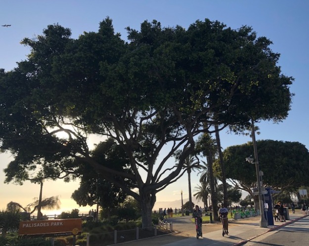
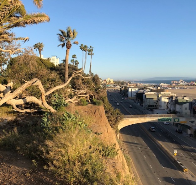
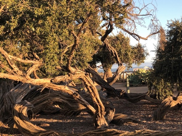
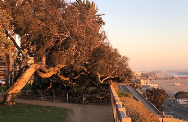
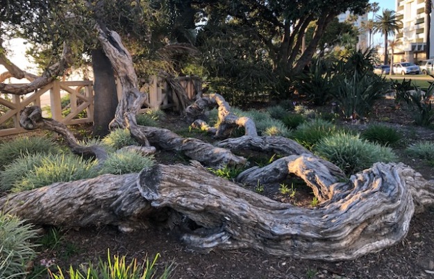
Kinney was the apostle of the eucalyptus, that Australian import that he hoped would cover the “bare, treeless, arid plains” of California with marketable timber. Urbane, handsome and cultured, Kinney had cultivated the socially susceptible Dona Baker, and gotten her to grant him a research plot in Rustic Canyon, the first forestry research facility in the U.S. In gratitude he filled Arcadia’s public park on the bluffs with the exotic specimens of the Antipodes. The trees are now over a hundred years old, and gloriously sculpted by the constant Bay breeze into the fractal forms of frozen time.
Kinney’s hopes for eucalyptus as an American hardwood were dashed, as fast as a falling eucalyptus branch; the cracking, twisting, splitting wood is no good as timber. The legacy of Kinney’s crusade means a California plagued by useless and destructive, but beautiful, naturalized eucalypts; but it also includes the arboretum that is Palisades Park.
More fortunate, was that Sen. Jones’s Long Wharf also failed. Santa Monica never became the Gateway to the Indies; today the area isn’t choked by diesel and warehouses, but a world beauty spot. Maybe that became clear to the Senator, who also loved the bluff gardens, and reputedly came here every day with his dogs to watch the sunset, until the day he died.
Sen. Jones’s memorial, with traditional palm.
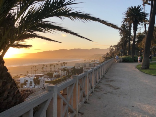
View south to Palos Verdes
…and north to Malibu.
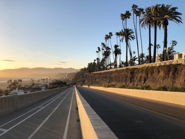
The California Incline
Arcadia’s paradise awaits the intrepid soul that dares look over the western rim of the world.
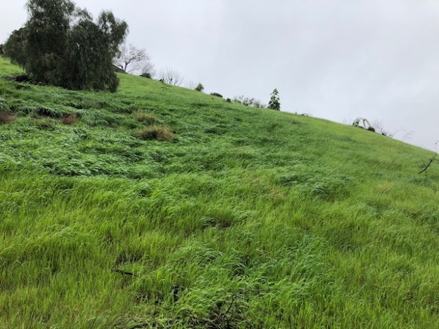
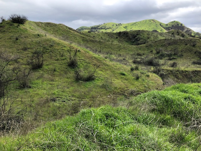
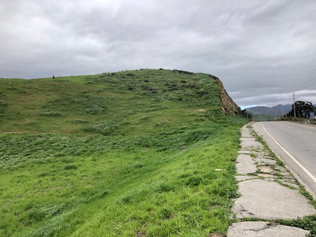
Winter rains bring out the Spanish in California. If a growth of grass like this year’s had come in the ranching period, the herds of Mexican longhorns would have increased past counting. The profits from the tallow-and-hide trade with the Yankees at San Pedro would have been a cause for setting off fireworks. Ramona’s Allesandro would have grown so drowsy counting the sheep in his flock, he might have lain down in the hills for a ten year snooze, like Rip Van Winkle. Andres Pico never saw it looking so lush and fat. But this is the Spanish winter green that he, and the Franciscans, labored to create.
A landscape that was re-grassed for, and by, European stock animals.
How did it happen so quickly? You can’t make bricks without straw. It explains why the Missions took so long (the 1790s, really) to get up their great adobe buildings.
“ And Pharaoh saith, Go ye, get you straw where ye can find it: yet not ought of your work shall be diminished. So the people were scattered abroad throughout all the land of Egypt to gather stubble instead of straw…
And the taskmasters hasted them, saying, Fulfil your works, your daily tasks, as when there was straw. And the…children of Israel…were beaten, and…cried unto Pharaoh, saying, Wherefore dealest thou thus with thy servants?…There is no straw given unto thy servants, and they say to us, Make brick: and, behold, thy servants are beaten; but the fault is in thine own people.”
Exodus 5
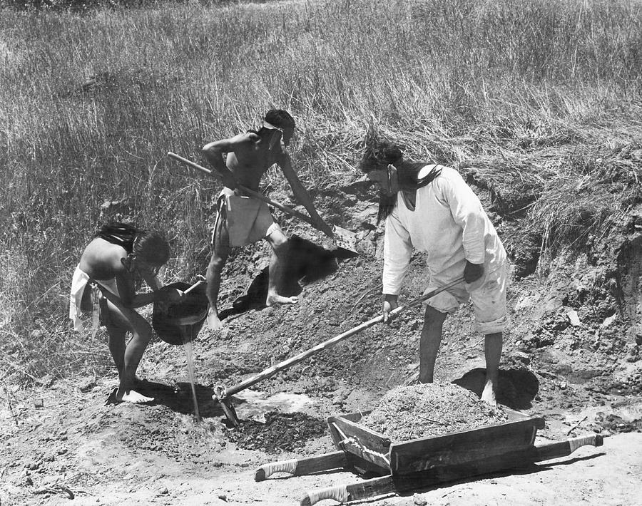
Mission San Fernando was the largest adobe complex ever built in California. Adobe bricks themselves cure in the sun; but if they are not covered with a tile roof and slathered with gleaming whitewash, they slump into mud with the first rain, just like the hills. Now, terra-cotta tile, and quicklime for whitewash, had to be fired in kilns, and kilns had to be fueled with oak. (Don’t blame the padres entirely: most of the Mission quicklime was sold to the pobladores of Los Angeles, to whitewash their adobe casitas downtown.)
“Gen. Andres Pico and Two Old Indians at San Fernando Mission” (1865). Left to right in background: glimpses of Limekiln, Lopez, and Kagel Canyons.I’m pretty sure these are the Pacoima Hills at sunrise. That’s Tujunga Wash; the Verdugos; and, in a haze of purple mountain majesty, the distant San Gabriels fading away. 1883.Spanish grass pasture has taken over the thin, recent layer of fertile soil that masks the fact that these hills are essentially uplifted dunes of beach sand.
“The conversion of California’s grasslands to non-native grasslands began with European contact. European visitors and colonists introduced plants both intentionally and accidentally. Adobe bricks from the oldest portions of California’s missions (1791-1800s) contained remains of common barley (Hordeum vulgare), Italian ryegrass (Lolium multiflorum), redstem filaree (Erodium cicutarium), wild oat (Avena fatua), spiny sowthistle (Sonchus asper), curly dock (Rumex crispus), wild lettuce (Lactuca sp., wild mustard (Brassica sp.) and others (Hendry 1931).
Most of the nonnative and invasive plants in California originated from the Mediterranean region of Eurasia and North Africa. Exotic Mediterranean annual plants altered California’s native grasslands to such an extent that it has been called “the most spectacular biological invasion worldwide” (Kotanen 2004).”
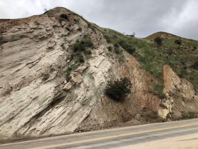
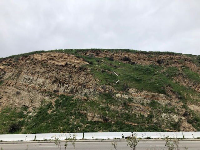
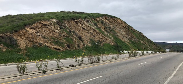
Land that is disturbed for any reason (fire, flood, landslide, man or beast traffic) gets immediately be re-colonized by the invasive grasses. Mudslides, in particular, displace native plants.
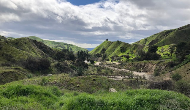
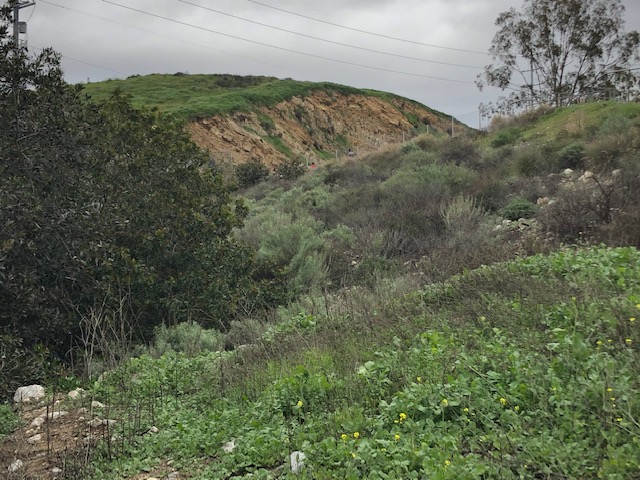
Three different green California hillsides.
The peculiar geology around Hansen Dam allows a View of three green communities, on three ridges. The middle ridge is a forgotten corner of the golf course. Somehow this olive-green hued knoll either retained, or re-grew after the Army Corps left, a native foothill chaparral flora: mature laurel sumac trees, shoulder-high sagebrush, buckwheat, cholla cactus, native sunflowers and bunch grasses. Above it, carpeting Top Hill., is the deep green of the naturalized Spanish/Mexican pasture grass mix, Old World foxtails and wild oats and rye and brome.
The bottom, bright green and yellow ridge is a small alluvial dump that just a week ago washed down from a new bridle path ramp. The disturbed soil immediately sprouted mustard shoots and turf weeds. The native plants nearby are putting out root; they won’t get a chance for a foothold until they set seed in the fall. If a hot summer burns off the “weeds”, the California natives might get a chance.
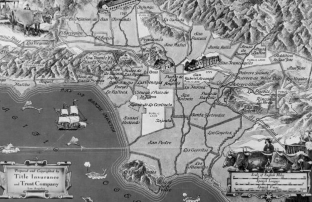
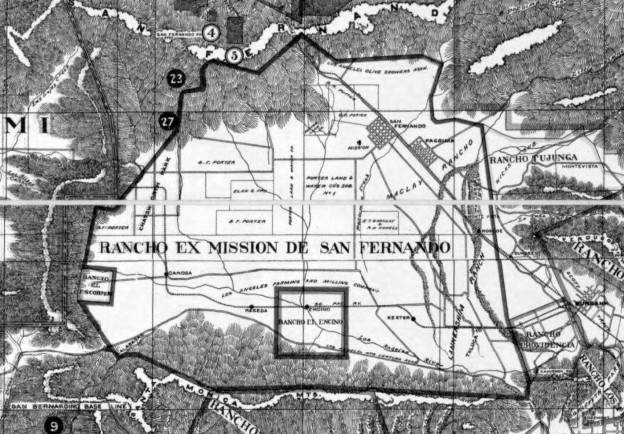
This map (undated: 1910?) makes clear how the “Old Spanish Grants” in the San Fernando Valley got broken down into subdivisions. The names “Lankershim” and “MacLay” and “Porter” ignore the fact that the original Castillian grant, of lands (but not waters) to be controlled (but not owned) by the Mission, was on behalf of the Tongva and Tataviam people of the Valley. This map shows how the Californios skipped over the Indians, but asserted Mission land rights for themselves, only to sell them to various Yankees at bankruptcy prices.
N.B.: The land that became Valley Village lies between the deathly fingers of the pre-concretized Tujunga Wash, and the hungry snake of the pre-concretized Los Angeles River. The confluence explains why there was no development here, except for orchards, until 1949. This part of North Hollywood was just too flood-prone. until after construction of Hansen Dam.
(Valley Village, by the way, was the district that put the peaches in the City of Lankershim’s epithet, “Land of the Peach.” Before 1940, the orchards here were frequently inundated by Tujunga floods.)