Tag Archives: Charles Maclay

The San Fernando Mission Olives

76 were planted, less than 50 remain. Most that are left seem in good shape, and are in good fruit.

“Why be contented with one olive tree,
When you could have a whole olive grove?
Why be content with a grove, when you could have
THE WORLD –??”

Wright and Forrest, “The Olive Tree” from KISMET

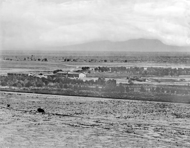
Around 1890, new Yankee cities were being carved out of the old Rancho ex-Mission San Fernando, and the smart money was clustered around the Southern Pacific right-of-way at the top of the Valley. The new rail cities became San Fernando and Chatsworth, and Sylmar and Pacoima. The big crop was olives; and many farmer-developers apparently made fortunes by pruning twigs off the old MIssion olive trees, rooting the cuttings, and re-planting the clones. In only a few years, the area had two or three of the biggest olive orchards History Has Ever Known.

The Franciscans’ Mission olives were planted for chrism, necessary for their rites. Olive, along with the Canary Island and Washingtonia palms, were introduced here for ritual purposes. And the sacred olives’ numerous progeny were eventually cured, branded, freighted down to LA in cans, then put on ships at the port of San Pedro. From there, they conquered the globe and Made Millions.

“In 1893, a group of Illinois businessmen purchased acres from the trustees of the Maclay Ranch east of the railroad tracks on San Fernando Road just south of Roxford Street and in 1894 began planting olives trees on up to 1,700 acres Experts were brought from France to supervise the work. Calling themselves the Los Angeles Olive Growers Association (in 1898 C.O. (Paul) Milltimore was the president and George L. Arnold the secretary), they built a packing plant and sold olives under the Tyler Olives label, later changing to the Sylmar Packing label. Sylmar’s olives became noted throughout the state for sweetness and purity. Chinese pickers were hired to harvest the crops, and up to 800 U.S. gallons (3,000 L) of olive oil a day were produced. The pickling plant was located on the corner of Roxford Street and San Fernando Road. By March 1898 about 200,000 trees had been planted,[15][19] and by 1906 the property had become the largest olive grove in the world. The first groves were planted with MissionNevadillo Blanco and Manzanillo olives.[15] Some Sevillano and Ascolano varieties were planted for extra-large fruit…

In 1904 the Sylmar brand olive oil won first place at the Louisiana Purchase Exposition, St. Louis, Missouri; in 1906 at the Lewis and Clark Centennial Exposition, Portland, Oregon;[23] and in 1915 at the Panama–Pacific International Exposition in San Francisco.

— From the Wikipedia entry on Sylmar

As far as I knew, and I’ve stomped all over the area, the Mission groves, and the commercial groves, had all been subdivided and developed. How great my joy, then, to find these while I was walking from the Orange Line Station at Chatsworth, seeking out the trailhead to the Old Stagecoach Road. These gifts of the Greeks line the last 1/2 mile of the quiet, horsey backstreet that, I now realize, is really the first “in-town” block of Chatsworth, the flat block after the Devil’s Slide, along the route of the ol’ Butterfield Stage.


I have no other information about Farmer Gray, but I do know, that the Butterfield family got into olive ranching in the Valley in a big way. Maybe Gray was an associate, or a tenant of theirs, or maybe his venture inspired the family to go in big on olives. At any rate, these tree were rooted over a hundred years ago, and are genetically identical — in fact, the living branches and cells of — the trees that the Franciscans and their Indian neophytes pruned and tended with their Own Hands. Pretty darn cool..especially to walk home under, after a hike to the the top of the Pass.

“…the vast San Fernando Plain”

I discovered this evocative photograph of the Valley (thank you KCET).

The view, taken on a cool drizzly day in 1875, is south, looking over what had been lands of the Mission San Fernando Rey de Espana, toward Mt. Cahuenga and the Cahuenga Pass. Los Angeles lies just over the hill.

The Valley was, in the Mexican period, historically contested land, the buckle of Alta California.  One army could camp at San Fernando and the other at the Cahuenga Pass, and they could lob cannonballs and race squadrons of cavalry at each other across the Valley floor.

John C. Fremont would have seen it looking much like this on the rainy January morning in 1847, as he rode from the Convento toward Campo de Cahuenga to receive the surrender of Gen. Don Andres Pico, and end the Mexican War in California. In fact, as Fremont knew, the whole plain was Pico’s land, Rancho Ex-Mission San Fernando. It must have especially galled Don Andres that Fremont and his Battalion of Bear Flag ruffians were camping there.

This view also was important to Gov. Juan Bautista Alvarado in 1836, during his coup d’etat. Southern Californios, led by the Pico Brothers and the Carrillo clan, had camped with their militia at San Fernando Mission. The rebels hoped to sever Southern California from the tyranny of Monterey, and to spite the treachery of Alvarado; but to do so they had to defend their capital of Los Angeles, and head off Alvarado’s Norteno army at the Pass. Bloodshed on this plain by fathers and sons on both sides was a real threat, but the Surenos finally acquiesced to Alvarado’s rule.  Soon after, the land grants began, and the loyal Surenos weren’t stinted.

This strategic plain was also the site of the Californio rebellions against the Mexican Governors Micheltorena and Victoria. These Battles of Cahuenga and Providencia were violent and explosive, and they had real political consequences. But casualties were almost nil, intentionally, of course.

The land was shaped this way by the Franciscans, with orchards, arable, and rangelands. It was then managed by Don Andres Pico, and his mayordomo Valentin Lopez. Tongva and Tataviam Indians were the vaqueros and orchardmen who worked the ranch. It appears here roughly in the condition in which it was sold off by the Picos to Isaac Lankershim for his huge dry-wheat farms and farmstead tracts; and to Charles Maclay for his City of San Fernando. The line of oaks in the center marks the San Fernando Road.

This is the landscape as Collis P. Huntington and his SPRR engineers saw it. In fact this may have been a surveyor’s photograph: a year later, in 1876, they and thousands of Chinese workers drove the tracks of the Southern Pacific Railroad right down that line of oaks, along San Fernando Road, and changed this view forever.

The Mission lands ran to the line of mist before the hills. This is roughly the line of the Los Angeles River. Here, in the cool shade of Cahuenga, the beautiful mountain that looks like a lady lying down, was the Tongva Council Grove of Sycamores (by the Gene Autry National Center in Griffith Park.)  Beyond the River, most of the hill-scape you see was Col. Griffith J. Griffith’s portion of the old Rancho Los Feliz. Today it is Griffith Park.

The Convento of the Mission appears still in good shape, but the church, the farmyard and outbuildings (including possibly the Andres Pico Adobe?) are muddy piles. Charles Fletcher Lummis would find the ruins in even worse shape ten years later. Appalled by the decrepitude of California antiquities, Fletcher founded the Landmarks Club to rally public forces in Los Angeles and across the nation to preserve San Fernando, and three other Missions.

Land that became North Hollywood and Valley Village appears here, at the center far right, between the orchards and the low-sloping Cahuenga Pass.

Happy New Year, and Season’s Greetings from Beautiful Valley Village. Prospero anyo!

Note the clear, golden sunlight in Valley Village. Tonight marks the 60th anniversary (1957) of a forgotten moment in Los Angeles history: the last night upon which the old brick trash incinerators, like the one over my shoulder, could be lit in the San Fernando Valley. This one served 12 families from 1949 to 1957.

The newly-ferocious smog by 1953 (an L.A. historical watershed period, in so many ways) had finally caused the City to enact regulations to do whatever they could to reduce it in 1954 – barring regulating automobiles. Everything that could be imagined to cause smog that wasn’t a car, was shuttered and banned. This included paint factories downtown, and backyard incinerators in the newly-suburban Valley.

Of course trash and paint contributed to smog, and ought to have been phased out, but it wasn’t for another 15 years that everyone admitted what had to be admitted – the internal combustion engine caused 9/10s of L,A.’s smog. 

Note the cracks in the masonry from earthquakes past. For all the effort we have put into our making our patio garden the swankest in Valley Village, the hovering pile of bricks makes it a true California garden: while out picking kumquats or lemonade berry or rosemary or red chard, you’re vulnerable to having this ton of bricks fall on your head at any minute. 

“My God! This is the Garden of Eden!” – Charles Maclay

Along the path beside the L.A. River through Studio City, there rises from her burrow, on a warm sunny day, this fantastic serpent sculpture, suitably framed at this season by the bright red edible berries of the manzanita.

Iconography: local fauna; but also, of course, the various readings of the Wisdom of the Serpent. In addition, Charles Maclay, when he first glimpsed this lush part of the Valley from the summit of the Cahuenga Pass in 1874, reportedly exclaimed “My God, this is the Garden of Eden.” Learning that the waters that made the broad, hill-sheltered plain (now Studio City) so green and fertile belonged to Los Angeles, Maclay continued up the old Mission road (Vineland? Laurel Canyon?) twelve or so miles to the area around the old Mission, then lying in ruins. VVV readers may remember the Mission land had always had abundant aquifers to feed its wells. There Maclay found the wells, water unclaimed by the Pueblo, and thus there he founded his city, the City of San Fernando. 

Perhaps his quote of astonishment while taking the “Valley Village View,” inspired the artist; perhaps it might inspire readers to explore the modern Valley.