


Half an hour from Valley Village, upstream from the Hansen Dam in Big Tujunga Canyon just after it becomes the Angeles Forest, lies Trail Canyon, which some call “Golden Creek.” It discharges into Big Tujunga Creek, thus its waters are in the LA river watershed.
I have to restate that, or I’ll scarcely believe it: these mountains are in the City of LA.

After the Forest Service took over, a trail went in along “Trail Canyon,” and it became a popular LA hiking spot, for it leads to a magnificent waterfall.
Trail Canyon Trail?
= “Trail” as a placer gold-mining term, meaning, “enough gold flakes in the stream to make you hike to the top to try to dig out the motherlode.” This one was a false trail, with only incidental gold and no motherlode; but the name stuck, as did a few prospector cabins, now retreats for those whose gold is digital, notional, weightless, un-panned, dreamt of.


The Brother wanted to hike with me here years ago, but I told him we couldn’t — the calamitous Station Fire of 2009 had forced the Forest Service to close Big Tujunga Canyon Road, and almost the entire watershed. (That was back when wildfires were still shocking disasters.) There are ruins all through the Big Tujunga Canyon area, from a century of fire and flood. This one in Trail Canyon was pretty evocative.


A decade after the fire, the trail is open. This is magnificent country. It was the very last stand of the California Grizzly. It has mountains and scenery as beautiful as any in California.


The diagonals of the canyon create diagonal planes of air and light, which get echoed in the clouds, and in the branch patterns of the trees. Stunning.

The great snake of the Tujunga Wash rampages across the Valley, through North Hollywood and the farmland on its outskirts. This is the land that became Valley Village.
The street bisecting the top third of the photo seems to be Laurel Canyon Blvd., then known as “Pacoima Blvd.” after its destination, Pacoima, the foothill district at the top of the Valley. Pacoima was the marshy pooling plain of the various Tujunga waters. In this photo, Pacoima is at top right.
Pacoima means “the entrance” — meaning, the entrance to the huge canyons of the Tujunga watershed. For the Tataviam, Pacoima was a welcoming gateway, a lobby where their various canyon clans met and traded, a game-rich forecourt, one of their favorite and most sacred home territories.
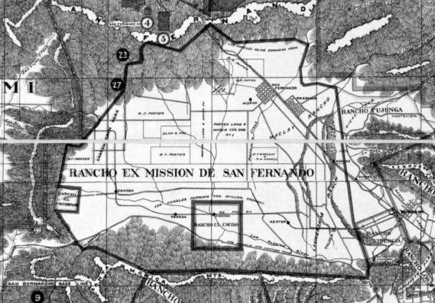
This map (undated: 1910?) makes clear how the “Old Spanish Grants” in the San Fernando Valley got broken down into subdivisions. The names “Lankershim” and “MacLay” and “Porter” ignore the fact that the original Castillian grant, of lands (but not waters) to be controlled (but not owned) by the Mission, was on behalf of the Tongva and Tataviam people of the Valley. This map shows how the Californios skipped over the Indians, but asserted Mission land rights for themselves, only to sell them to various Yankees at bankruptcy prices.
N.B.: The land that became Valley Village lies between the deathly fingers of the pre-concretized Tujunga Wash, and the hungry snake of the pre-concretized Los Angeles River. The confluence explains why there was no development here, except for orchards, until 1949. This part of North Hollywood was just too flood-prone. until after construction of Hansen Dam.
(Valley Village, by the way, was the district that put the peaches in the City of Lankershim’s epithet, “Land of the Peach.” Before 1940, the orchards here were frequently inundated by Tujunga floods.)
